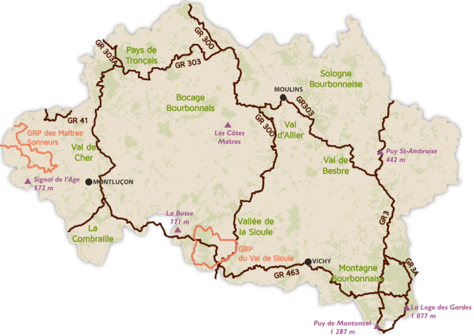
Hiking in the Allier |
|
GR300 |
The route of Saint-Jacques-de-Compostelle in the Bourbonnais
This path, which crosses the Allier from north to south, gives new life to an old pilgrimage route with which gathered former pilgrims from the north of France and even further from Puy-en-Velay to go to Saint-Jacques de Compostela.
Read more |
GR3 |
From the meadows and fields of the Besbre valley to the wooded reliefs of the Montagne Bourbonnaise, this route will take you to Puy de Montoncel, the highest point of the department with its 1,287 meters.
Read more |
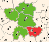
GR463 |
An integral crossing of the historic south of Bourbonnais through the GR463, which makes it an exceptional belvedere thanks to its East-West orientation! This 170 km long road allows the crossing between the GR46 and the GR3 and offers a crossing of the southern department of Allier, that is to say the historic Bourbonnais, because their contours are almost the same.
Read more |
GRP Val du Sioule |
Located south of the Allier, on the edge of the volcanoes of Auvergne, Val de Sioule is one of the most popular places in the Auvergne.The variety and the charm of its landscapes offer different possibilities of discoveries in the vineyards of Saint-Pourçain, along the steep gorges of Sioule between Chouvigny and Ebreuil, not far from the forest of Colettes which formerly concentrated an intense mineralogical activity around the extraction of kaolin. The Val de Sioule is also remarkable for the diversity of its heritage, between castles along the gorges, characteristic villages, Roman bridges and Romanesque churches. The vineyards of Saint-Pourcin, a small vineyard in the heart of Bourbonnais and now the AOC, are the opportunity for a well-deserved stopover in one of the 18 wineries to taste its wines, once served at the table of kings of France.!
Read more |
GRP des Maitres Sonneurs |
Between Berry and Bourbonnais, a trail follows the initiatory route of the pipelines described by George Sand in his novel The Masters Sonneurs.
This 185 km long trail winds through the countryside of central France in the form of an elongated circuit that crosses three sections: Indre, Cher and Allier.The trail in the Allier is 58 km, almost a third of the total, in the westernmost part of the department.
Read more
|
Le rocher Saint-Vincent |
Witnesses of historical sites steeped in history, overlooking the Sichon Valley, the rock St. Vincent (private property) is one of the most typical sites of the Bourbon mountains that offers a remarkable panoramic view.
Distance: 7 km
Level: very easy
Altitude difference: 206 m
Read more |
Notre Dame de la Defense |
The hilly landscape on the heights of Bellenaves offers a great number of remarkable points of view, including the panorama from the Green Plateau, at the doors of the forest of Colettes.
Distance: 15,5 km
Level: easy
Altitude difference: 300 m
Read more |
Le gour de l'Annet |
Long hikes in the famous beech forest in the heart of the forest of Colettes, descent into the secret valley of Veauce ... an immersion in the tree people.
Distance: 22 km
Level: difficult
Altitude difference: 370 m
Continuez... |
Le roc du Vacher |
A path overlooking the Loire Valley, the plain of Forez and the city of Roanne: you will enjoy the view from north to south, the Morvan, the Lyonnais mountains and the Alps, the opposite of the chain of Puys (Puy deDome and Puy de Sancy).
Distance: 7 km
Level: very easy
Altitude difference: 206 m
Read more |
Autour de la cascade de la Pisserote |
This path will allow you to discover the beautiful and picturesque valley of the Bourbonnaise Barbenan mountain and many points of view.Large and imposing upstream of Arfeuilles, it is tumultuous in the gorges located downstream of the mill of Mas, where cascades and waterfalls follow one another, a little further, the rapids of the Pisserote.
Distance: 12 km
Level: easy
Altitude difference: 332 m
Read more |
Le puy du roc |
Monumental Romanesque church, old houses, granite farms, panoramic views of the Auvergne mountains and small secret valleys, Châtel-Montagne once operated one of the roads connecting the valleys of the Loire and Allier.
Distance: 9 km
Level: very easy
Altitude difference: 400 m
Read more
|

 Creuse